The Paper: “A Study of the Kaimuki Community,” 1939
The Writer: S. K.
Location in RASRL: Box A-3
The Map
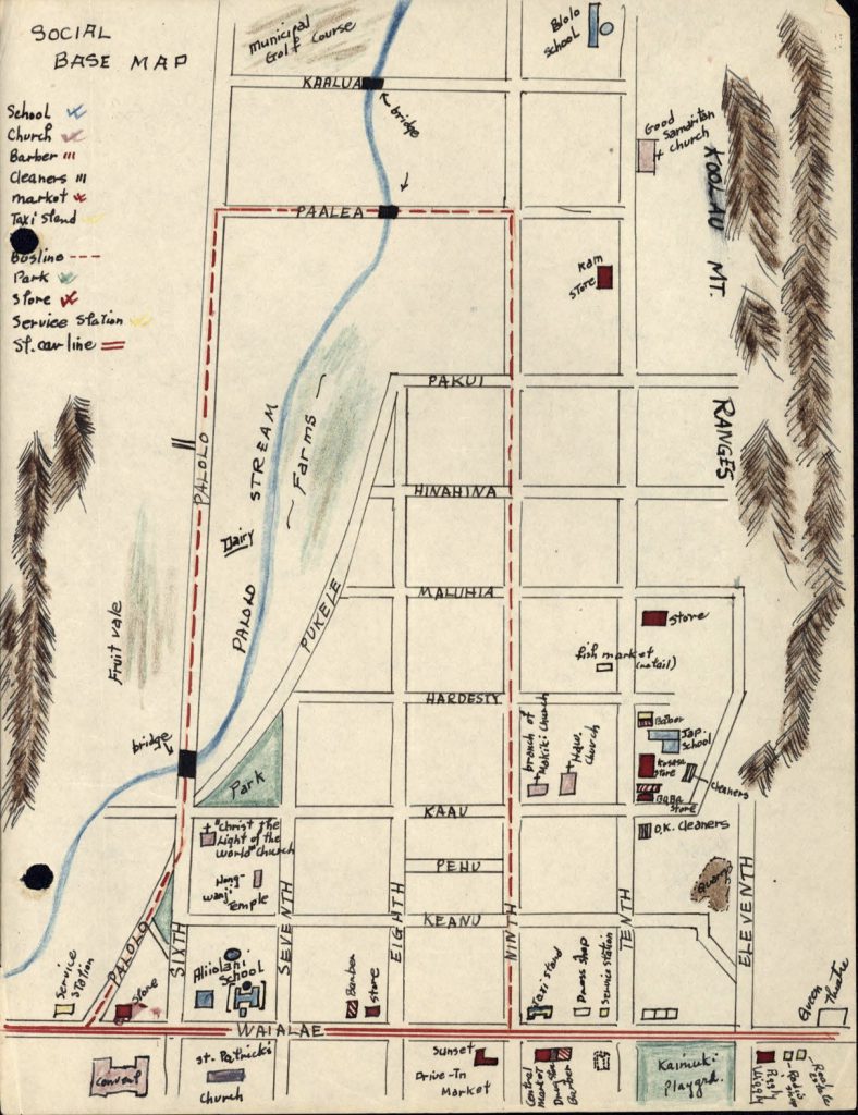
S.K.’s map is as meticulous as her paper. Both are precise and neither shows extraneous information or unnecessary deviations from the subject at hand. The map was attached to the original paper, rendered on an ordinary 8 ½ x 11 inch paper. S.K. used colored pencils to differentiate the natural features of the neighborhood, most notably the Ko‘olau mountains on either side of the community and Pālolo Stream, which marks a boundary between the newer residential areas from the older rural agricultural areas. The map shows how Kaimukī was changing – vestiges of its rural past exist alongside the more modern community she grew up in. The dairy, a fruit vale, and farms were still significant enough features to warrant documentation. The developers of Kaimukī laid out the neighborhoods in neat, equally divided blocks, the numbered avenues running mauka to makai. But the physical features of Pālolo, the stream running down the west side of the district and the mountains and ridges, were natural barriers that could not be made to conform to a system of suburban street grids.
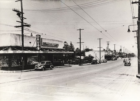
Most of the businesses in Kaimukī developed around Wai‘alae Avenue. The most striking feature is the number of grocery stores and markets, seven in all. (The writer does not explain the difference, but size seems to be the most important distinction.) Four are along 10th Avenue, most crowded around the intersection with Ka‘au Street. S.K. names one store (Baba Store) and shows the name of the proprietor on the other (Kosasa Store). The other stores are located along Wai‘alae Avenue. Two are unnamed. The other three are larger grocery stores, Piggly Wiggly, Central Market, and Sunset Drive-In Market. Piggly Wiggly, a national chain store, opened in 1928. It was later bought out by Theo Davies Company, one of the “Big Five” corporations (“Hawai‘i Modernism Context Study” Historic Hawai‘i Foundation, prepared by Fund Associates, November, 2011, pp. 4-12).

Piggly Wiggly Market, Wai‘alae Avenue (Source: UrbanPlanet.org)
The second largest number of institutions on the map are churches, six in all. The Catholic church, St. Patrick’s, also has a school and convent. The Hongwanji or Jodo Shinshu Buddhist temple lies across the street from the Calvary Church. S.K. describes it as “…the most elaborate, next to St. Patrick’s. The windows are painted with scenes from the Scripture and a huge sign on the steeple announces ‘Jesus is the Light of the World.'” (On the map, the sign reads “Christ the Light of the World Church.”) There is also an Episcopal church, Good Samaritan, a multi-ethnic parish with a Japanese pastor; a Christian Hawaiian church; and a Japanese Congregationalist church that was “a branch of the Makiki Japanese Church” (Makiki Christian Church was founded in 1904 by Rev. Takie Okumura.)
There are four schools on S.K.’s map: Pālolo, Ali‘iōlani, St. Patrick’s, and the Japanese language school. Ali‘iōlani was a newly opened English Standard elementary school, one of the first three established in the 1920s along with Thomas Jefferson and Kapālama. The schools were established in the 1920s at the demand of White Americans, new immigrants from the continent and military families who feared that their children’s education was being “held back due to the large numbers of children who had trouble with the language” (Judith Hughes, “The Demise of the English Standard School in Hawai‘i.” Hawaiian Journal of History, vol. 27 1993, p. 71). These coast Haole, as they were sometimes known, petitioned the Department of Public Instruction to create what amounted to a segregated school system where language proficiency was a proxy for race.
S.K.’s map does not show houses or designate ethnic enclaves. Although Japanese were not the largest group in the area, the presence of two Japanese markets (Kosasa and Baba) near the Japanese schools indicates that many Japanese residents lived nearby. Interestingly, the Japanese school and Hongwanji are not adjacent to one another, which is unusual because the Buddhist priest or his wife often doubled as the Japanese language teacher.

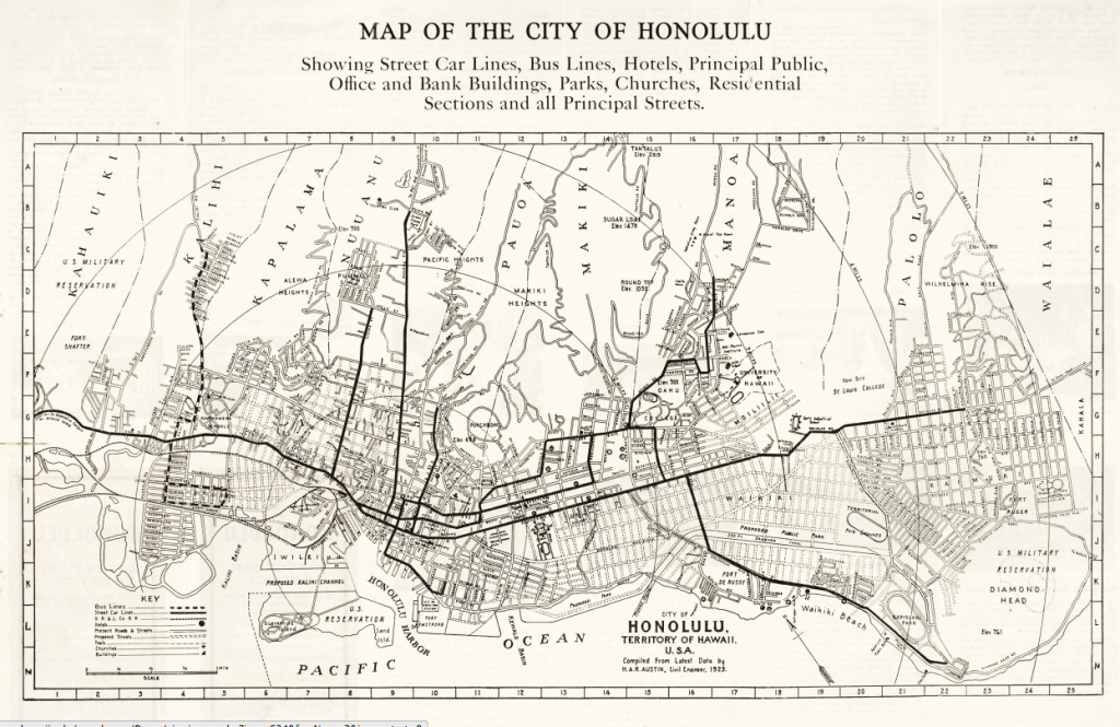
Honolulu map showing Streetcar and Bus Lines (Source: University of Hawai‘i at Mānoa Digital Collection)
Kaimukī was only three miles from downtown Honolulu but to some early residents it was “the country.” Throughout the 1920s and 1930s Honolulu Rapid Transit expanded service in the area, adding a streetcar that traveled along Wai‘alae Avenue. A bus line ran into the valley along Pālolo Avenue as far as Pa‘alea Street and returned to Wai‘alae by way of 9th Avenue. Another bus line that ran up into the Valley along Pālolo Avenue connected Pālolo Valley to Wai‘alae Avenue.
Residents and institutions out of reach of public transportation aren’t shown on the map. The Chinese Old Men’s Home, for example, was situated far up the ridge at the end of 10th Avenue. S.K. describes the residents as “independent,” possibly because the home was located in a part of Pālolo Valley that was inaccessible by bus or streetcar. ” …[T]heir wants are not very great because their age restricts them from engaging in various activities.” The home was founded in 1920, a project of several charitable agencies who took on the challenge of caring for men who had no families or the means to care for themselves or return to China. According to Xin Liu:
… the Pacific Commercial Advertiser reported that there were about thirty-one well-known Chinese beggars in the city, some of them blind and some lame. Some business stores in Chinatown placed an open bag of rice on their doorsteps topped with a rice bowl. Any destitute person could help himself to a bowl of rice if needed. Some Chinese restaurants also gave their leftovers to beggars making their daily rounds (“Founding and Development of Palolo Chinese Home, 1917-1967,” Chinese America: History and Perspectives, p 3.).
The Paper
We know that the maps and papers in the RASRL collection were assignments, term papers that were turned in at the end of the semester for a grade. Part of the assignment was to integrate what they learned into their work, applying their knowledge in their research. Students accomplished this in a number of ways – S.K. chose to articulate the concepts she would be illustrating up front in a paragraph that quickly dispenses with this part of the assignment. The focus of her paper is the concept of “succession” through the “invasion” of ethnic and social groups and how a community changed as a result. Although some features of this theory could be applied to Kaimukī, others were absent or up-ended by Kaimukī’s being a suburban development. For example, in an ordinary community, “invasion” took place when “… a group of inferior economic or cultural status moves into an area occupied by a group possessing superior status.” In the case of Kaimukī, however, the older residents – dairy herders, quarry workers, and farmers – were driven further into the valley, away from the middle class suburban development that, by 1939 when this paper was written, was the dominant feature of the community.
S.K.’s paper does not provide a detailed discussion of the ethnic character of the community, nor does her map show where residents lived, perhaps because the population was spread out over a relatively large area. The most notable feature is Kaimukī’s large White population. She says that a number of “navy” families rented homes in Kaimukī, but neither the map nor the paper describes something that was relatively unusual – a Honolulu neighborhood with a large White population. S.K. says that “Other Caucasians” were the largest group but doesn’t provide any numerical evidence or detailed description of the population other than the fact that of the area’s 2,118 residents, 1,839 were American citizens. Of that number only 760 were the children of “foreign born” parents. A large number of American citizens whose parents were foreign born would indicate a larger number of Japanese residents, but S.K. lists them as the fourth largest group in Kaimukī after Haole, Chinese, and Caucasian-Hawaiians. Therefore, since the majority of the population were American citizens whose parents were born in the United States, we can conclude that most of Kaimikī’s residents were White.
Other indications of Kaimukī’s middle class status is the amount of leisure time the residents enjoy and the pervasiveness of consumer goods – washing machines, radios, telephones, and indoor plumbing. The presence of three large markets, one operated by a company in California, also suggests that Kaimukī was a place that catered to Hawai‘i residents from the continent.
The Writer
Although it lacks personal details, S.K.’s paper indicates that she grew up in Kaimukī. She describes watching the cows from her classroom window and excursions into Pālolo Valley:
In those days, we followed the trodden-down path, made by the cows and horses, in search of guava and mountain apples further up the valley. It was not altogether too pleasant, for the … scratches we received were inevitable. Today, it is but a matter of a few minutes to travel the district in an automobile which formerly took us over an hour’s time.
S.K. was part of the very small Korean community in Hawai‘i. She was probably the daughter of Korean immigrants who arrived in one of two waves, between 1903-05 or 1910-1924. Political unrest and the Japanese annexation of Korea in 1910 hampered any natural flow of immigrants to Hawai‘i. Therefore, Koreans were the smallest Asian immigrant group in Hawai‘i – 4,533 in 1910, 4,950 in 1920, 6,461 in 1930, and 6,851 in 1940.
S.K. attended the English Standard School, Ali‘iōlani. Unless she attended a private school, she would have graduated from McKinley High School before going on to the University of Hawai‘i. The 1930s were a time of tremendous growth at UH. The student population reached 1,000 in 1931-32 when the Normal school was absorbed by the University. By the time she graduated, UH had nearly 2,000 students.
Korean students were always a minority at UH, which reflected their relatively small numbers in the Territory. The University kept but did not always publicize the ethnic backgrounds of the student population. Racial data was not included in the annual report to the Territorial legislature, but RASRL students ostensibly had access to this information, most likely from the Registrar. Information compiled in the RASRL collection shows that before 1930, the number of Korean students at UH measured in the single digits, but beginning in the 1930s, the number of students rose steadily.
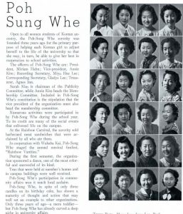
S.K. belonged to Poh Sung Whe, a Korean sorority founded in 1935. Many of UH’s social organizations were ethnic cultural groups. Although there were occasional calls to abandon this practice on the grounds that these groups exacerbated racial tension, these social organizations reflected life in the Territory more than the more vaunted international or trans-racial organizations such as the YMCA. Students did not necessarily see a conflict between their belief in Americanization and their desire to socialize with people who shared their language, culture, and family backgrounds.
Social Historical Context
Kaimukī was part of the ahupua‘a of Pālolo that belonged to Lunalilo. The area was sparsely populated because it was hot and dry with few natural sources of water. The high ridges, however, made Kaimukī a convenient lookout: after landing at Waikīkī, Kamehameha I sent scouts to the top of the hill to follow the movements of Kalanikupule’s army (John Takasaki, “Kaimuki,” Hawaiian Journal of History, vol. 10 1976, p. 66). Kaimukī was later used by surveyors as a triangulation station or “trig point” – a fixed point from which surveyors determine distances between locations. Kaimukī Hill is also known as “Telegraph Hill” because it was used to signal the arrival of ships moving toward Honolulu Harbor from either Koko Head or Barber’s Point (Takasaki, p. 64). In 1887, Daniel Paul Rice Isenberg leased part of the land from Lunalilo and established a ranch that was used for “cattle, alfalfa and blooded race horses” (Takasaki, p. 67).
Isenberg later purchased more property in Kaimukī from George P. Trousseau, a French doctor who served as a physician to Lunalilo. In 1898, Gear, Lansing and Co., a real estate development company, bought 260 acres from Isenberg and began to subdivide the land into house lots. Their intention was to create a suburb of comfortable single family homes. Unfortunately, Kaimukī had no natural water supply, was out of reach of the streetcars, and the red dirt that covered the area stained everything it touched. Kaimukī’s population expanded when refugees from the 1900 Chinatown fire began to relocate and build businesses along Wai‘alae Avenue. Gear and Lansing eventually built infrastructure, including roads and a pumping station; in 1903 the Honolulu Rapid Transit extended service to Kaimukī, which made the area more attractive and accessible to the rest of Honolulu. Once the streets were paved and sidewalks were built in 1925, the community grew more rapidly.
In addition to dairy farms, Kaimukī was also the location of the largest rock quarry on O‘ahu. It was founded in 1908 and operated by Honolulu Construction and Draying (HC&D). The explosions from the quarry were heard for miles around, and before safer techniques were developed, debris was scattered throughout the neighborhood. Beatrice Krauss, a researcher who worked for the Pineapple Research Institute, complained that the rocks thrown from the quarry shattered the glass of her greenhouse (Kelcey Ebisu, “From Stone Quarry to Athletic Center: The Makai Campus,” Building a Rainbow: A History of the Building and Grounds of the University of Hawaii Campus, p. 170).
RASRL Context
There are very few maps or papers in the RASRL collection that deal with areas that might be considered “suburban” or areas of Honolulu where middle and upper class residents lived. This could be because most of the RASRL writers were working class students and wrote about their own homes and experiences. It might also be that, given the Sociology Department’s focus on immigrants, assimilation, and social problems, Kāhala and Mānoa were much less likely to be scrutinized.
Kaimukī seems to occupy space between two worlds. It is physically situated between a rural, agricultural landscape and a modern urban setting. It also exists between the local working class in neighborhoods like Kalihi and Kaka‘ako and wealthy communities occupied by Hawaii’s elites. What goes unscrutinized and therefore unseen is absent from the RASRL collection, outside the frame of reference, an invitation for further exploration.

